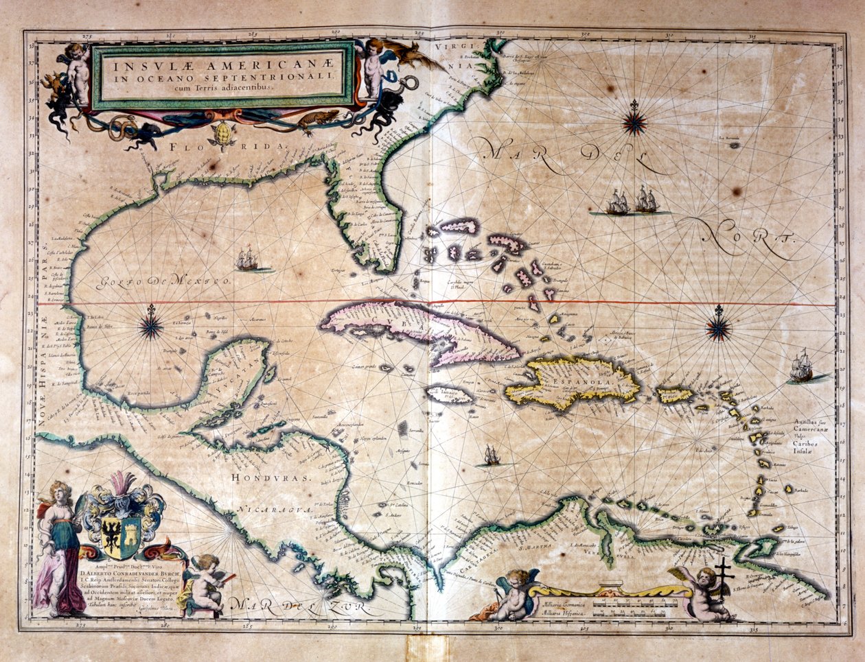
The Caribbean Sea: Gulf of Mexico and Caribbean Sea from the Atlas of Wilhelm Blaeu by Willem Blaeu

The Caribbean Sea: Gulf of Mexico and Caribbean Sea from the Atlas of Wilhelm Blaeu


Willem Blaeu

€ 0.00
Enthält ??% MwSt.
   Add to cart
   Configure art print
Undated  ·  engraving  ·  Picture ID: 1052199

Nonclassified artists

The Caribbean Sea: Gulf of Mexico and Caribbean Sea from the Atlas of Wilhelm Blaeu by Willem Blaeu. Available as an art print on canvas, photo paper, watercolor board, uncoated paper or Japanese paper.
Other color variations of this picture  
zu Favoriten hinzufügen   Add to favorites    Select wall color    View painting in a room AR/3D   View in 3D / AR
0 Reviews

Configure art print

Picture Frame

Medium & Stretcher

Glass & Passepartout

Miscellaneous & Extras

 Save / compare configuration
Preview Icon

Summary

Gemälde
Veredelung
Keilrahmen
Museumslizenz

€ ???.??
(inkl. 20% MwSt)
   Add to cart

Produktionszeit: 2-4 Werktage
Bildschärfe: PERFEKT

Should you desire adjustments to brightness and color, or a custom crop of the motif, we are happy to make these changes at no additional cost to you. Please do not hesitate to contact us.

Similar artworks selected for you

Pascaart van de Noort Zee verthoonende in zich alle de Custen en havens daer rontom gelegen Map of Africa, India, Indian Ocean and East Indies Map of Central America A Chart Bound in Van Keulen Map of Florida and Cuba Chart of the Western Atlantic East Indies, from A chart of the North Sea Map of the Mexican Archipelago Map of America, from the Mercator Atlas, published by Jodocus Hondius, Amsterdam, 1606 Africa, Europe and Part of Americas, from Atlas of the World in Thirty-Three Maps, by Battista Agnese Territorial holdings of the Dutch West India Company, 1710 A general chart of the northern navigation The Carybsche Eylanden of Barbados to the bend of Mexico Isle of Rugen, Germany (engraving) Bermuda, in Daniel Keller. Asiae nova descriptio (Antwerp, 1590) Map of A chart of the sea coasts of new England, New Jersey, Virginia, Maryland and Carolina from Cape Cod to Cape Hatteras Map of the Pacific, China and America, 1589 Argentina, Chile, Strait of Magellan, Land of Fuego, in Western Atlantic Ocean Map of New Spain, New Galicia and Guatemala, 1625 The Pacific Ocean Maris Pacifici The Famous West Indian Voyage Made by the English Fleet of 23 Ships and Barks Map of the island of Malta
Show more similar artworks

Other art prints by Willem Blaeu

Map of Europe. Atlas by William Blaeu (1571 - 1638). Amsterdam 1635 Map of Europe Map of Africa. Plate from an Atlas by Willem Janszoon Blaeu Atlas Willem Janszoon Blaeu (1571 - 1638) Map of Republic of Genoa, Italy Map of Andalusia, Spain Map of the Moscow Kremlin Castellum Urbis Moskvae, Russia, 1597 Map of Sicily, from Regionum Italiae, engraving The Caribbean Sea: The Bermuda Triangle between the Bermuda Archipelago, Miami, and Puerto Rico. According to Wilhelm Blaeu Map of the Molucca Islands east of Indonesia Map of polar regions, by Dutch cartographer Willem Janszoon Blaeu Nova Orbis Geographica ac Totius Terrarum Hydrographica Earth Globe Made by Willem Blaeu (Detail) of a Sea Monster from a Terrestrial Globe, 1645-48 Geographic map of the 17th century Dutch Atlas by Wilhelm Blaeu showing American and Canadian territories fur animal peoples. The North is below according to medieval custom.
Discover more works by Willem Blaeu

Excerpt from our top sellers

Blue Cave Reclining Female Nude with Spread Legs Two Girls Moon rising Over the Sea The Oceanids Mending the Sail, 1896 Christ in the House of His Parents, 1863 Lady with Peacock Fan Still Life with Cherries and Peaches Lamia The Stages of Life Arm of the Seine near Vétheuil The Interior of the Palm House Breakfast Time Napoleon I Bonaparte studying at the Royal Military School of Brienne. Its shadow falls on the geographic map of Europe. Illustration by Jacques Marie Gaston Onfray de Breville dit JOB
Show More Artworks


What our customers think about us


Frequently Asked Questions about Meisterdrucke


Personalizing your art print at Meisterdrucke is a simple and intuitive process that allows you to design an artwork exactly to your specifications: Choose a frame, determine the image size, decide on a printing medium, and add suitable glazing or a stretcher frame. We also offer customization options such as mats, fillets, and spacers. Our customer service is available to help you design your perfect artwork.

At Meisterdrucke, you have the fascinating option to visualize the artwork you configured directly in your own space. For a tailored preview, simply upload a photo of your room and let the artwork appear on it. If you visit us via a mobile device, be it a phone or tablet, our augmented reality feature brings the image to life and seamlessly projects it into your space. An experience that uniquely combines art and technology.

Choosing the medium is often a matter of personal taste. To give you a clearer idea, we have provided some images for each medium. For a holistic experience, we also offer you a sample set of all paper variants so you can make a decision not just visually but also haptically. You can take advantage of the sample set free of charge – only the shipping costs will apply. You can order the sample set directly.

Do not worry. At Meisterdrucke, we do not proceed mechanically. We manually review each order. If there are any inconsistencies or peculiarities in the configuration, we will immediately contact you. Of course, our courteous and patient support is always at your side to assist you with the configuration. Together with you, we adjust your image by phone or email so that the final result exactly meets your expectations.


Do you have any questions?

Are you interested in an art print from our manufactory but still unsure? Do you need advice on choosing the medium or help with the order?

Our experts are happy to assist you.

+43 4257 29415
support@meisterdrucke.com
Mo-Do: 7:00 - 16:00 | Fr: 7:00 - 13:00

Do you have any questions?

Are you interested in an art print from our manufactory but still unsure? Do you need advice on choosing the medium or help with the order?

Our experts are happy to assist you.

+43 4257 29415
support@meisterdrucke.com
Mo-Do: 7:00 - 16:00 | Fr: 7:00 - 13:00


Meisterdrucke

   Kärntner Strasse 46
        9586 Finkenstein am Faaker See
        Austria
        +43 4257 29415
        support@meisterdrucke.com
Other languages

                   
Erfahrungen & Bewertungen zu Meisterdrucke
Partner Logos

Kaiser Franz Joseph

Meisterdrucke
Kärntner Strasse 46
9586 Finkenstein am Faaker See · Austria
+43 4257 29415 · office@meisterdrucke.com
Partner Logos


(c) 2023 meisterdrucke.ie