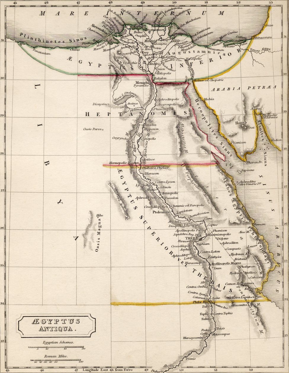
Map of Ancient Egypt, drawn and engraved by Sydney Hall, c.1826 by Sydney Prior Hall

Map of Ancient Egypt, drawn and engraved by Sydney Hall, c.1826

(Map of Aegyptus Antiqua (Ancient Egypt), drawn and engraved by Sydney Hall, c.1826 )


Sydney Prior Hall

€ 131.33
Enthält 13.5% MwSt.
   Configure art print
Undated  ·  coloured engraving  ·  Picture ID: 59372

Illustration  ·  Cartography

Map of Ancient Egypt, drawn and engraved by Sydney Hall, c.1826 by Sydney Prior Hall. Available as an art print on canvas, photo paper, watercolor board, uncoated paper or Japanese paper.
mapping · cartography · geography · north africa · historical · river nile · red sea · desert · mediterranean · delta · Private Collection / Bridgeman Images
zu Favoriten hinzufügen   Add to favorites    Select wall color    View painting in a room AR/3D   View in 3D / AR
0 Reviews

Configure art print

Picture Frame

Medium & Stretcher

Glass & Passepartout

Miscellaneous & Extras

 Save / compare configuration
Preview Icon

Summary

Gemälde
Veredelung
Keilrahmen
Museumslizenz

€ 131.33
(inkl. 20% MwSt)
   Add to cart

Bildschärfe: PERFEKT

Should you desire adjustments to brightness and color, or a custom crop of the motif, we are happy to make these changes at no additional cost to you. Please do not hesitate to contact us.

Similar artworks selected for you

Egypt, or the Land of Mizraim Map of Syria, Mesopotamia, Assyria, from A Map of the British and French Dominions in America Ancient Egypt. Map. Egypt and Abyssinia Arabia, the Persian Gulf and the Red Sea, with Egypt, Nubia and Abyssinia, from Map of Egypt, 1902 A New Map of Mexico and Adjacent Provinces The Places Recorded in the Five Books of Moses Egypt and Syria in the 19th century - engraving in West Coast of Africa, from Lisbon to Sierra Leone, from Map of Aquitaine (France) Paraguay Province of Rio de la Plata with Adjacent Regions Tucuman and Santa Cruz de la Sierra Eastern Part of Canada, Northern Nova Scotia and Part of Labrador, Engraving by G. Zuliani Egypt with the Sinai Peninsula and the Journeys of the Israelites Map of Mesopotamia Abyssinia and the Shores of the Red Sea Historical Atlas of Mesopotamia. Babylonia, Syria and Assyria. End of 18th century Journeyings of the Israelites, from Egypt to the Land of Canaan Northern Mexico, from Map of Egypt, Nubia (Sudan) and Abyssinia (Ethiopia) Chile, from the South of Peru to Cape Horn, from Illustration from the book Atlas of All Parts of the Earth by unknown author and published by Chr. Steen & Søn (Copenhagen, 1857) Pennsylvania, New York, southern New Jersey, with the western part of Connecticut, Massachusetts Bay and Land of the Iroquois, engraving by G. Zuliani taken from Tome I of the Land of the Ottawa and Kilistine Indians Around Lake Superior and a Supplement of Eastern Florida, Engraving by G. Zuliani from Tome I of the "Newest Atlas" Overland Route to India States of the Grand Seigneur in Asia - Empire of Persia, Land of the Uzbeks, Arabia and Egypt Map of Palestine also showing the boundaries of each tribe. A. Stucchi
Show more similar artworks

Other art prints by Sydney Prior Hall

The Eruption of Mount Vesuvius, a Lava Torrent The Wasps of Aristophanes at King Map of Ancient Egypt, drawn and engraved by Sydney Hall, c.1826 The Tichborne Case, Further Sketches in Court The Royal Visit to Ireland Prince George of Greece and Denmark, high commissioner of Crete, at home in Athens, 1898 The Marquis of Lorne and the Princess Louise in Canada, Tobogganing at Ottawa An Autumn Tour in Switzerland, VII, Climbing Mont Blanc The King in his Home at Marlborough House, His Majesty in his Study Portrait of Charles Stewart Parnell To Klondyke for Gold, at the Foot of the Chilcoot Pass Old Folks and Fashions near Lewes, Sussex A Hard-Worked Minister in the House of Lords, Lord Lansdowne speaking The First of May at Oxford, the Choir of Magdalen College Welcoming the Rising Sun with a Hymn Sir Garnet Wolseley
Discover more works by Sydney Prior Hall

Other motives from the category Cartography

Map Showing the route of the Armada fleet, engraved by Augustine Ryther A New Land and Water Map of the Entire Earth Map of Roman Kent, England, from Map of the Battle of Talavera, Published by William Blackwood and Sons, Edinburgh and London, 1848 Map of Venice, first half of 17th century Insurance Map of the City of Philadelphia; volume 2, plate15, 1887 Map of Europe at the Time of the Third Crusade, 1190, from Detail of Copy of a Catalan Map of Europe and North Africa, presented to Charles V of France in 1381 Map of Antwerp, from Map of the Coast of New England, Observed and Described by Captain John Smith (1580-1631) 1614, from Map of Sixteenth Century France, from the Map of Bergen, from A New and Correct Map of the Roads of England Map of the Battle of Vitoria, published by William Blackwood and Sons, Edinburgh and London, 1848 Map of Novara, from
View More from "Cartography"

Excerpt from our top sellers

The Gull Satan Viewing the Ascent to Heaven Composition VIII, 1915 Old Woman and Boy with Candles Soft Hard Lisbeth The Quarrel of Oberon and Titania The White Cat Study of a Lion The Port at Sunset, Opus 236 The Olive Trees The Last Supper Heath Princess Polyphonically Painted White The Seasons: Autumn, 1896
Show More Artworks


What our customers think about us


Frequently Asked Questions about Meisterdrucke


Personalizing your art print at Meisterdrucke is a simple and intuitive process that allows you to design an artwork exactly to your specifications: Choose a frame, determine the image size, decide on a printing medium, and add suitable glazing or a stretcher frame. We also offer customization options such as mats, fillets, and spacers. Our customer service is available to help you design your perfect artwork.

At Meisterdrucke, you have the fascinating option to visualize the artwork you configured directly in your own space. For a tailored preview, simply upload a photo of your room and let the artwork appear on it. If you visit us via a mobile device, be it a phone or tablet, our augmented reality feature brings the image to life and seamlessly projects it into your space. An experience that uniquely combines art and technology.

Choosing the medium is often a matter of personal taste. To give you a clearer idea, we have provided some images for each medium. For a holistic experience, we also offer you a sample set of all paper variants so you can make a decision not just visually but also haptically. You can take advantage of the sample set free of charge – only the shipping costs will apply. You can order the sample set directly.

Do not worry. At Meisterdrucke, we do not proceed mechanically. We manually review each order. If there are any inconsistencies or peculiarities in the configuration, we will immediately contact you. Of course, our courteous and patient support is always at your side to assist you with the configuration. Together with you, we adjust your image by phone or email so that the final result exactly meets your expectations.


Do you have any questions?

Are you interested in an art print from our manufactory but still unsure? Do you need advice on choosing the medium or help with the order?

Our experts are happy to assist you.

+43 4257 29415
support@meisterdrucke.com
Mo-Do: 7:00 - 16:00 | Fr: 7:00 - 13:00

Do you have any questions?

Are you interested in an art print from our manufactory but still unsure? Do you need advice on choosing the medium or help with the order?

Our experts are happy to assist you.

+43 4257 29415
support@meisterdrucke.com
Mo-Do: 7:00 - 16:00 | Fr: 7:00 - 13:00


Meisterdrucke

   Kärntner Strasse 46
        9586 Finkenstein am Faaker See
        Austria
        +43 4257 29415
        support@meisterdrucke.com
Other languages

                   
Erfahrungen & Bewertungen zu Meisterdrucke
Partner Logos

Kaiser Franz Joseph

Meisterdrucke
Kärntner Strasse 46
9586 Finkenstein am Faaker See · Austria
+43 4257 29415 · office@meisterdrucke.com
Partner Logos


(c) 2025 meisterdrucke.ie