Search by artist, work title or style – e.g. Monet, Starry Night, Impressionism, Hokusai wave, nude. Describe the scene – e.g. green meadow, abstract with lots of red, dark oil painting, standing nude next to a tree.

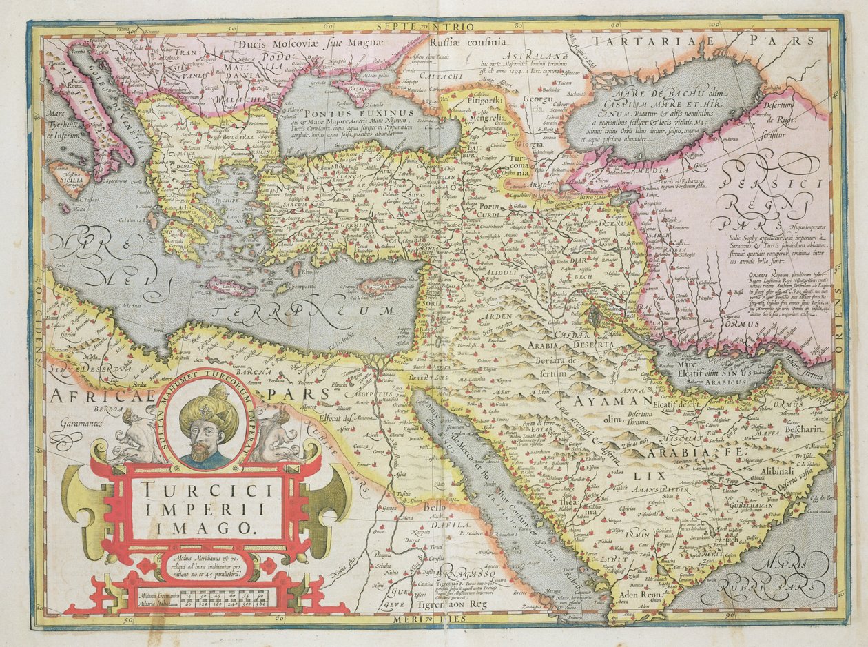
Map of the Turkish Empire, from the Mercator Atlas pub. by Jodocus Hondius Amsterdam, 1606 by Dutch School

Map of the Turkish Empire, from the Mercator Atlas pub. by Jodocus Hondius Amsterdam, 1606

(Map of the Turkish Empire, from the Mercator Atlas pub. by Jodocus Hondius (1563-1612) Amsterdam, 1606 )


Dutch School

€ 137.81
Enthält 13.5% MwSt.
   Configure art print
1606  ·  coloured engraving  ·  Picture ID: 415267

Cultural Circles  ·  Cartography

Map of the Turkish Empire, from the Mercator Atlas pub. by Jodocus Hondius Amsterdam, 1606 by Dutch School. Available as an art print on canvas, photo paper, watercolor board, uncoated paper or Japanese paper.
ottoman · turk · turkey · print · cartouche · sultan mahommed · Private Collection / Bridgeman Images
Other color variations of this picture  
AR/3D   View in 3D / AR zu Favoriten hinzufügen   Add to favorites    Select wall color    View painting in a room

Note: Only reviews with comments are displayed. Reviews can be submitted directly after purchase in your customer account.

Configure art print

Picture Frame

Medium & Stretcher

Glass & Passepartout

Miscellaneous & Extras

 Save / compare configuration
Preview Icon

Summary

Gemälde
Veredelung
Keilrahmen
Museumslizenz

€ 137.81
(inkl. 20% MwSt)
   Add to cart

Bildschärfe: PERFEKT

Should you desire adjustments to brightness and color, or a custom crop of the motif, we are happy to make these changes at no additional cost to you. Please do not hesitate to contact us.

Similar artworks selected for you

Turkish Empire, in The Turkish Empire, from Map of the Middle East, from Theatrvm Orbis Terrarvm, 1570 1692 Map of the Turkish Empire in Europe, Asia and Africa The Turkish Empire Friuli, Italy - Slovenia (Istria) with the Gulf of Trieste and Balkans (engraving) Italy, Balkan Peninsula, Turkey, Lebanon, Syria, Israel, Jordan, Iraq, Arabian Peninsula, Iran Map of the Turkish Empire Map of Turkey, from Theatrum Orbis Terrarum Persian Empire, in Map of the Turkish Empire Turcici imperii descriptio Geography map of the territory of the Ottoman Empire taken from Croatia, Romania, Bosnia and Herzegovina, Serbia, Bulgaria, Montenegro, Kosovo, Albania, Macedonia, Greece, Turkey, south Russia, Georgia, Azerbaijan, Armenia, Iran, Iraq, Syria, Lebanon, Israel, Jordan, Saudi Arabia, Kuwait, Qatar, Bahrain, United Arab Em Palestine, in Map of Greece, from Theatrum Orbis Terrarum by Abraham Ortelius Map of Ottoman Empire Map of the Eastern Mediterranean and Black Sea countries, Turkey and the provinces of Asia Minor Justus Danckers East Europe, Asia and north Africa - by A Morocco, North Algeria, Tunisia, North-West Libya, Spain, Portugal, Italy Map of Greece History. Ancient Greece. The travels of Alexander the Great. Engraving in : Le theatre du monde, atlas by G. Blaeu, Amsterdam Map of North Africa and Europe Germany (State: Saxony), south Poland, large part of Ukraine (except north), west Czech Republic, Slovakia, east Austria, Hungary, Romania, Moldova, Slovenia, Croatia, Italy (east, central and south), Bosnia and Herzegovina, Serbia, Bulgaria, Montenegro 1700 Map of the Eastern Mediterranean Map of Persia (Iran), Armenia, Anatolia (Turkey) and Arabia (Arabian Peninsula: Saudi Arabia, Kuwait, United Arab Emirates, Oman, Qatar, Yemen, Bahrain) Janssonius Map of Persia
Show more similar artworks

Other art prints by Dutch School

Map of New Holland, Now Australia, and of New Zealand Martin Luther preaching (detail) A Dodo Plaque with a Chinoiserie Landscape and Gilt Details, c.1680 A Planisphere with Signs of Zodiac Terrarum Orbis Tabula (after G. a Schagen, c.1689) China Miracle of Our Lady of Nazare, Our Lady of Nazare Church, Portugal Compass Rose, from a Blaue Atlas, published in Amsterdam Map of Greece, Hungary and Their Surrounding Countries Interior of a Dutch House, 1st Half of 17th Century Tulips: from Verzameling van Bloemen naar deNatuur getekend (Collection of Flowers Drawn from Nature) Map of the Turkish Empire, from the Mercator Atlas pub. by Jodocus Hondius Amsterdam, 1606 The Coronation of William of Orange and Mary, at Westminster Abbey, 21st April 1689 Caricature of Luther, Calvin and Menno Simons disputing Christ and his teaching
Discover more works by Dutch School

Other motives from the category Cartography

The Kingdoms of England and Scotland, from an Atlas of the World in 33 Maps, Venice, 1st September 1553 (detail) Map of the Battle of Jena, published by William Blackwood and Sons, Edinburgh and London, 1848 Map of Paris depicting the city Map of the Siege of St Sebastian, published by William Blackwood and Sons, Edinburgh and London, 1848 Map of Flanders, after cartographer Matthias Quad from his Map depicting plantations on the Mississippi River from Natchez to New Orleans Map of Palestine, from Theatrvm Orbis Terrarvm, 1570 Map of Palestine, Palestina Antiqua, from Map of Epirus for Map of the Middle East, from Theatrvm Orbis Terrarvm, 1570 A Map of the Island of Juan Fernandez, Printed in Map of Animals in Africa Map of the mouth of the Chicago River, Illinois with the plan of the proposed piers for improving the harbour Cyclorama fold out map detailing the History of the Great Rebellion, c.1870 Map of Asia, Published in 1700, Paris
View More from "Cartography"

Excerpt from our top sellers

Man and Woman, Embrace Woman at the Window Moonlight over Lake Lucerne Accent in Rose, 1926 The Artist Shichiri Beach in Sagami Province After the Bath Boys Bathing The Girl with a Pearl Earring A Corner of the Garden at Montgeron, 1876-7 The Scream P.S. Krøyer The Consummation of Empire The Zaporozhye Cossacks Writing a Letter to the Turkish Sultan Circe Offering the Cup to Ulysses, 1891
Show More Artworks


What our customers think about us


Frequently Asked Questions about Meisterdrucke


Personalizing your art print at Meisterdrucke is a simple and intuitive process that allows you to design an artwork exactly to your specifications: Choose a frame, determine the image size, decide on a printing medium, and add suitable glazing or a stretcher frame. We also offer customization options such as mats, fillets, and spacers. Our customer service is available to help you design your perfect artwork.

At Meisterdrucke, you have the fascinating option to visualize the artwork you configured directly in your own space. For a tailored preview, simply upload a photo of your room and let the artwork appear on it. If you visit us via a mobile device, be it a phone or tablet, our augmented reality feature brings the image to life and seamlessly projects it into your space. An experience that uniquely combines art and technology.

Choosing the medium is often a matter of personal taste. To give you a clearer idea, we have provided some images for each medium. For a holistic experience, we also offer you a sample set of all paper variants so you can make a decision not just visually but also haptically. You can take advantage of the sample set free of charge – only the shipping costs will apply. You can order the sample set directly.

Do not worry. At Meisterdrucke, we do not proceed mechanically. We manually review each order. If there are any inconsistencies or peculiarities in the configuration, we will immediately contact you. Of course, our courteous and patient support is always at your side to assist you with the configuration. Together with you, we adjust your image by phone or email so that the final result exactly meets your expectations.


Do you have any questions?

Are you interested in an art print from our manufactory but still unsure? Do you need advice on choosing the medium or help with the order?

Our experts are happy to assist you.

+43 4257 29415
support@meisterdrucke.com
Mo-Do: 7:00 - 16:00 | Fr: 7:00 - 13:00

Do you have any questions?

Are you interested in an art print from our manufactory but still unsure? Do you need advice on choosing the medium or help with the order?

Our experts are happy to assist you.

+43 4257 29415
support@meisterdrucke.com
Mo-Do: 7:00 - 16:00 | Fr: 7:00 - 13:00


Meisterdrucke

   Kärntner Strasse 46
        9586 Finkenstein am Faaker See
        Austria
        +43 4257 29415
        support@meisterdrucke.com
Other languages

                   
Erfahrungen & Bewertungen zu Meisterdrucke
Post.at DHL Express Quehenberger Cargoboard
Kaiser Franz Joseph

Meisterdrucke
Kärntner Strasse 46
9586 Finkenstein am Faaker See · Austria
+43 4257 29415 · office@meisterdrucke.com
Post.at DHL Express Quehenberger Cargoboard


Meisterdrucke 2759 Bewertungen auf ProvenExpert.com

(c) 2025 meisterdrucke.ie