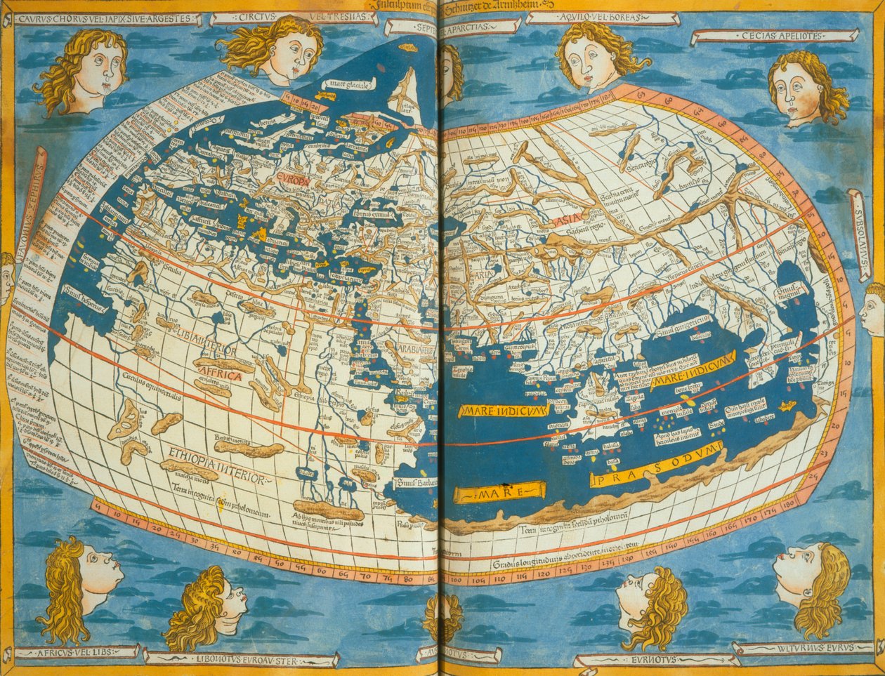
Map of the world, based on descriptions and co-ordinates given in

Map of the world, based on descriptions and co-ordinates given in 'Geographia' first published in Ulm, Germany, 1482

(Map of the world, based on descriptions and co-ordinates given in 'Geographia' first published in Ulm, Germany, 1482 )


Ptolemy

€ 129.46
Enthält 13.5% MwSt.
   Configure art print
1482  ·  colour lithograph  ·  Picture ID: 297511

Ancient Art  ·  Cartography

Map of the world, based on descriptions and co-ordinates given in 'Geographia' first published in Ulm, Germany, 1482 by Ptolemy. Available as an art print on canvas, photo paper, watercolor board, uncoated paper or Japanese paper.
winds · cherubs · coordinates · atlas · continents · roman egypt · renaissance · Newberry Library, Chicago, Illinois, USA / Bridgeman Images
Other color variations of this picture  
zu Favoriten hinzufügen   Add to favorites    Select wall color    View painting in a room AR/3D   View in 3D / AR

Note: Only reviews with comments are displayed. Reviews can be submitted directly after purchase in your customer account.

Configure art print

Picture Frame

Medium & Stretcher

Glass & Passepartout

Miscellaneous & Extras

 Save / compare configuration
Preview Icon

Summary

Gemälde
Veredelung
Keilrahmen
Museumslizenz

€ 129.46
(inkl. 20% MwSt)
   Add to cart

Bildschärfe: PERFEKT

Should you desire adjustments to brightness and color, or a custom crop of the motif, we are happy to make these changes at no additional cost to you. Please do not hesitate to contact us.

Similar artworks selected for you

Map of the world Atlas of Borso d Ms Lat 463 Fol.75v-76r Map of the World with the Twelve Winds Map of the world, based on descriptions and co-ordinates given in Map of the world, based on descriptions and co-ordinates given in A World Map as Written Down by Ptolemy by Laurent Fries from Gaspar Trechsel Oval Planisphere of the World Showing Magellan Claudii Ptholemaei Alexandrini Liber Geographiae cum Tabulis et Universali Figura et cum Additione Locorum Quae a Recentioribus Reperta Sunt Diligenti Cura Emendatus et Impressus The World A Map of the World, 1511 Map tracing Magellan Planisphere (or World Map) New Board for All the World Map of the World based on a description by Ptolemaeus World Map, Mundu [sic] Spericum... Cognosces Diligentia Joani Mathei Contareni, by Contarini, Giovanni and Francesco Rosselli World map World map of the navigator Sebastiano Caboto (Sebastien Cabot) 1544 Map of the World New and World Map from the Blaeu Atlas Large Planisphere, or Mappa Mondo of 1459, by Mauro Frau Le Grand Atlas, ou Cosmographie Blauiane, en laquelle est exactement descritte le Terre, la Mer, et le Ciel, vol.I Geographia by Ptolemy
Show more similar artworks

Other art prints by Ptolemy

Map of the world, based on descriptions and co-ordinates given in Map of the known world, from Map of North Africa and West Africa, published in Strasbourg in 1522 Map Depicting the North of Africa, from an Atlas by Ptolemy, 1st Half 16th Century Map of Arabia, the Persian Gulf and the Indian Sea Map of Spain and Portugal, from Map of Phoenicia, Mesopotamia and Babylon Map of the World, 1486 Map of the British Isles, from Map of Central Europe (detail) Map of Africa, Plate 18 from an Atlas of the World, 1486 Map of the World, Based on Descriptions and Coordinates Given in Map of France, from Map of Gaul, Belgium, Lyon and Aquitaine Map of Southern Africa (published in Strasbourg in 1522)
Discover more works by Ptolemy

Other motives from the category Cartography

A Map of the World, Corrected from the Observations Communicated to the Royal Societies of London and Paris, to the Right Honourable Richard Boyle View of Quebec, cartouche of a map depicting St. Lawrence River from Sorel, 1699 Map of the Acropolis of the 2nd city at Troy Map of the Battle of Trafalgar, published by William Blackwood and Sons, Edinburgh and London, 1848 Map of Rovigo, from Map of the Spice Islands from an Account of the Voyage of Ferdinand Magellan A Map Showing the Passage of the Shadow of the Moon Over England on 22 April 1715, Engraved by John Senex, 1715 Map from Gulliver Map of the Suez Canal, c.1870 Map of Sussex Double Hemisphere World Map, 1587 Map of Persia, 1638 Double Hemisphere World Map Septentrionalium terrarum descriptio, map of the Arctic, 1595 Map of Florence, 1584
View More from "Cartography"

Excerpt from our top sellers

The Alexander Mosaic, depicting the Battle of Issus between Alexander the Great and Darius III in 333 BC, Roman floor mosaic removed from the Casa del Fauno Study for The Bookworm Tiger Sailing Ships St. Paul The Plague Comes View of L Reclining Female Nude School of Athens, from the Stanza della Segnatura, 1510-11 Cattleya Orchid and Three Hummingbirds Reclining Nude Woman Reading a Book Effect of Spring, Giverny, 1890 Garden in Giverny Angel Musician
Show More Artworks


What our customers think about us


Frequently Asked Questions about Meisterdrucke


Personalizing your art print at Meisterdrucke is a simple and intuitive process that allows you to design an artwork exactly to your specifications: Choose a frame, determine the image size, decide on a printing medium, and add suitable glazing or a stretcher frame. We also offer customization options such as mats, fillets, and spacers. Our customer service is available to help you design your perfect artwork.

At Meisterdrucke, you have the fascinating option to visualize the artwork you configured directly in your own space. For a tailored preview, simply upload a photo of your room and let the artwork appear on it. If you visit us via a mobile device, be it a phone or tablet, our augmented reality feature brings the image to life and seamlessly projects it into your space. An experience that uniquely combines art and technology.

Choosing the medium is often a matter of personal taste. To give you a clearer idea, we have provided some images for each medium. For a holistic experience, we also offer you a sample set of all paper variants so you can make a decision not just visually but also haptically. You can take advantage of the sample set free of charge – only the shipping costs will apply. You can order the sample set directly.

Do not worry. At Meisterdrucke, we do not proceed mechanically. We manually review each order. If there are any inconsistencies or peculiarities in the configuration, we will immediately contact you. Of course, our courteous and patient support is always at your side to assist you with the configuration. Together with you, we adjust your image by phone or email so that the final result exactly meets your expectations.


Do you have any questions?

Are you interested in an art print from our manufactory but still unsure? Do you need advice on choosing the medium or help with the order?

Our experts are happy to assist you.

+43 4257 29415
support@meisterdrucke.com
Mo-Do: 7:00 - 16:00 | Fr: 7:00 - 13:00

Do you have any questions?

Are you interested in an art print from our manufactory but still unsure? Do you need advice on choosing the medium or help with the order?

Our experts are happy to assist you.

+43 4257 29415
support@meisterdrucke.com
Mo-Do: 7:00 - 16:00 | Fr: 7:00 - 13:00


Meisterdrucke

   Kärntner Strasse 46
        9586 Finkenstein am Faaker See
        Austria
        +43 4257 29415
        support@meisterdrucke.com
Other languages

                   
Erfahrungen & Bewertungen zu Meisterdrucke
Partner Logos

Kaiser Franz Joseph

Meisterdrucke
Kärntner Strasse 46
9586 Finkenstein am Faaker See · Austria
+43 4257 29415 · office@meisterdrucke.com
Partner Logos


(c) 2025 meisterdrucke.ie