")
support@meisterdrucke.com · 0043 4257 29415


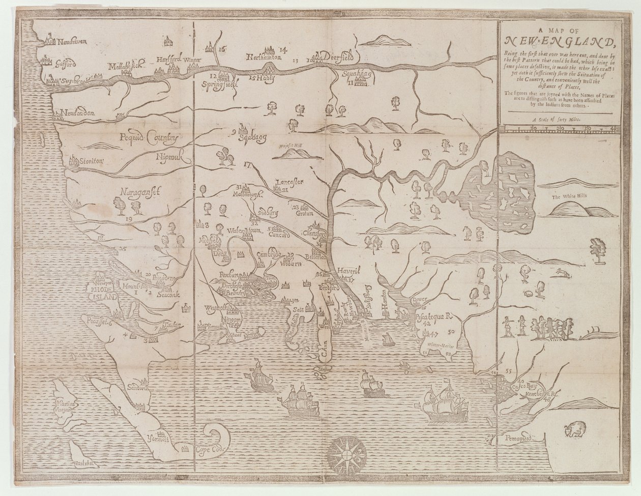
'Map of New England, Being the first that ever was here cut...'('Map of New England, Being the first that ever was here cut...', 1677 )John Foster |
|
|
€ 131.33
Enthält 13.5% MwSt.
|
|
|
1677 · Holzschnitt
· Picture ID: 223682
east coast of america · boston · cape cod · newport · new london · massachusetts · connecticut · rhode island · new hampshire · Massachusetts Historical Society, Boston, MA, USA / Bridgeman Images
|
|
| 0 Reviews |


.jpg)
.jpg)
.jpg)
.jpg)
.jpg)
.jpg)
.jpg "Siege of Saint-Omer")
.jpg "Valloton")
_-_(MeisterDrucke-1515060).jpg "A Map of the Country and City of Panama. Part. 3 : Chap : 5. (engraving)")
.jpg "Map of the Battle of Landen")
.jpg "The Principality of Orange and Comtat Venaissin")
.jpg "Map of the Siege of Palmanova")
.jpg "Map of Northern Norway with Enlarged Sections of Vardø and Kildin by Willem Barents")
.jpg "Plan of the Glorious Action Near Pultawa in Ukraine Between the Armies of Tsar Peter the Great of Russia and King Charles XII of Sweden, June 27 - July 8, 1709")
.jpg "A coloured chart of Plymouth Harbour, and of the country up to Tavistock; drawn possibly by Robert Spry")
.jpg "Map of Chile Compiled by Jesuits")
.jpg "Project for the construction of a channel of communication between the Atlantic Ocean and the Mediterranean Sea, including part approximately between Toulouse and Pexiora; in the regions of Midi-Pyrenees and Languedoc-Roussillon, France")
.jpg "French Guiana, South America")
.jpg "Naval Battle in the Sound, 1658")
.jpg "Project for the construction of a channel of communication between the Atlantic ocean and the Mediterranean sea, inclusive part approximately between Capestang and Étang de Thau; in the regions of Languedoc-Roussillon, France")
_-_(MeisterDrucke-1087495).jpg "Connecticut")
.jpg "Louis XIV Atlas, map of Collioure")
.jpg "Map of the Canal du Midi, with its aqueducts")
.jpg "Map of the Island Dieuw or Diewij on the Coromandel Coast, India")
.jpg "Battle of Ter won by the King")
_from_Travel_account_-_(MeisterDrucke-1123712).jpg "City of Goa in India, Engraving by Theodor de Bry from Travel account of the voyage of the sailor Jan Huyghen van Linschoten to Portuguese East India 1579-1592")
.jpg "Speculum Romanae Magnificentiae: Ancient Rome, and its Hills, from the West, 1582")
.jpg "Allegorical Map of the Stages of Love")
.jpg "1646 Map of the Western Mediterranean and Gibraltar by Robert Dudley")
.jpg "Chart of the North Sea dedicated to")
.jpg "True Design of the Great Victory Against the Turkish Fleet, May 15, 1649")
.jpg "Toulon, France")
_-_(MeisterDrucke-1353072).jpg "The English Victory Against the Scots at Muskelbroghe, 1547")
 - (MeisterDrucke-58602).jpg "The East End and South Side of the Parthenon, c.1813")
.jpg "The Hippodrome, Constantinople")
.jpg "Richard Mather, First in a Line of New England Puritan Clergymen and Leader of New England Congregationalism")
.jpg "Temple of Theseus, Athens")
.jpg "Smyrna")
.jpg "The East End and South Side of the Parthenon")
.jpg "The Temple of Apollo Epicurius at Bassai, Phigalea")
.jpg "General View of the Temple of Apollo Epicurius at Bassai, Phigalea")
.jpg "Temple of Jupiter, Athens")
.jpg "Map of the world")
.jpg "Map of Andalusia, Spain")
.jpg "Map of the Andaman and Nicobar Islands, Bay of Bengal, 1898")
 - (MeisterDrucke-56912).jpg "Typus Orbis Terrarum, map of the world, from Ortelius")
 - (MeisterDrucke-87231).jpg "Map of British Southern India, 1872")
.jpg "Map of Palestine, Palestina Antiqua, from")
.jpg "Map of the known world, from")
.jpg "Reproduction of Map of Routes of St. James of Compostel, Originally Engraved by D. Serveaux 1648")
.jpg "The first western atlas map of China, from the Ortelius Theatrum atlas, 1584")
.jpg "Map of Florida, Canada and Labrador (from")
.jpg "Map Depicting The Invasions of England and Ireland With All Their Civil Wars Since the Conquest, c.1627")
.jpg "Map of Israel, from")
.jpg "Map of Mongolia showing Japan and China, c.1680 by Frederick de Wit")
 - (MeisterDrucke-201147).jpg "Map of the Battle of Pultusk, Published by William Blackwood and Sons, Edinburgh and London")
.jpg "Map of Le Marais, Paris")
.jpg "Study for")
.jpg "The Yellow Books, 1887")
.jpg "Joan of Arc, 1865")
.jpg "The Open Window")
.jpg "Irises")
.jpg "The Roses of Heliogabalus")
.jpg "Praying Hands")
.jpg "Water Serpents II")
.jpg "Sunset over Yalta")
.jpg "Noon, or The Siesta (after Millet)")
.jpg "The Seven Works of Mercy")
.jpg "Composition VII")
.jpg "Joan of Arc")
 1922 - (MeisterDrucke-647283).jpg "Blue")
.jpg "Cliff Walk at Pourville")